Poplar River First Nation: Droning for Climate Monitoring on Lake Winnipeg
Background
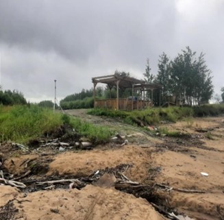
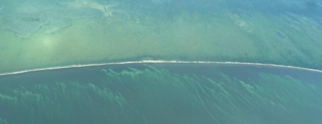
The Anishinabek of Poplar River have been stewards of their land for generations. Poplar River, located on the east side of Lake Winnipeg, is a remote First Nation community of 1,600 people. The community is accessible only by air or water during summer, with no roads connecting it to the rest of Manitoba. As a community reliant on the land for subsistence, the Anishinabek of Poplar River are deeply concerned about the impacts of climate change on their fisheries. Rising lake water temperatures and increased nutrients in the water are predicted to lead to more frequent and severe algal blooms. These blooms can foul fishing nets, causing financial losses for fishers, and harm aquatic life. Furthermore, studying shoreline erosion is crucial for recording changes and understanding potential impacts on community access to the lake and safety.
In addition to these concerns, Elders and land users have observed alarming changes in the local ecosystem such as the drying of vegetation near the community and in their traditional territory. This trend is particularly concerning, as the drying of peat soils increases the risk of devastating peat fires. These changes not only threaten community infrastructure and the safety of residents but also wildlife habitat, ultimately affecting the community’s ability to hunt, trap, and gather traditional foods.
Timeline of Poplar River’s efforts to protect their Traditional Lands:
- 1999 – Poplar River nominated protected lands under the Manitoba Assembly of Chiefs and the Manitoba Keewatinowi Okimakanak Memorandum of Understanding regarding protected areas in Manitoba.
- 2011 – This nomination led to the development of a land management plan, which was enacted into law designating the Traditional Lands known as Asatiwisipe Aki as a Protected Area.
- 2018 – The Pimachiowin Aki (‘The Land That Gives Life’), comprising the combined Traditional Lands of Poplar River, Pauingassi, Little Grand Rapids, and Bloodvein River First Nations, was designated as a UNESCO World Heritage Site.
About the project
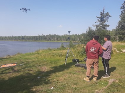
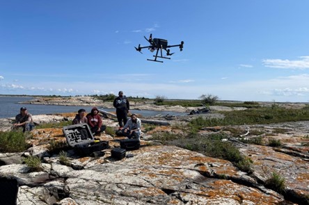
In 2018, the Poplar River First Nation launched their innovative Lands Guardian Program, marking the beginning of their community-based monitoring initiatives. As part of a vulnerability assessment, they initiated monitoring of peatlands for long-term drying trends. Building on this momentum, they secured funding in 2021 for the Poplar River First Nation Community Based Monitoring Project to expand their monitoring efforts, focusing on algal blooms, water quality, and shoreline erosion.
As part of this project, the Poplar River First Nation set the following goals:
- Achieve independence in monitoring their lands and waters, integrating scientific methods and traditional knowledge.
- Develop effective mitigation and adaptation strategies to enhance resilience against climate change impacts.
- Establish advanced monitoring capacity within the community, enabling meaningful contributions to monitoring programs while addressing the unique challenges of remoteness.
Resources
- To learn more about the project: Poplar River First Nation Community Based Monitoring Project
- Water Quality and Shoreline Erosion Monitoring Report
- Peat Monitoring Report
- Peatland Monitoring Sampling Protocol
- Short Documentary: The Lake Winnipeg Project: Poplar River